
Edwards County · Available
39.36 ACRES
Alamo Ranch · Tract 5
$171,216 · Ranch King of Texas
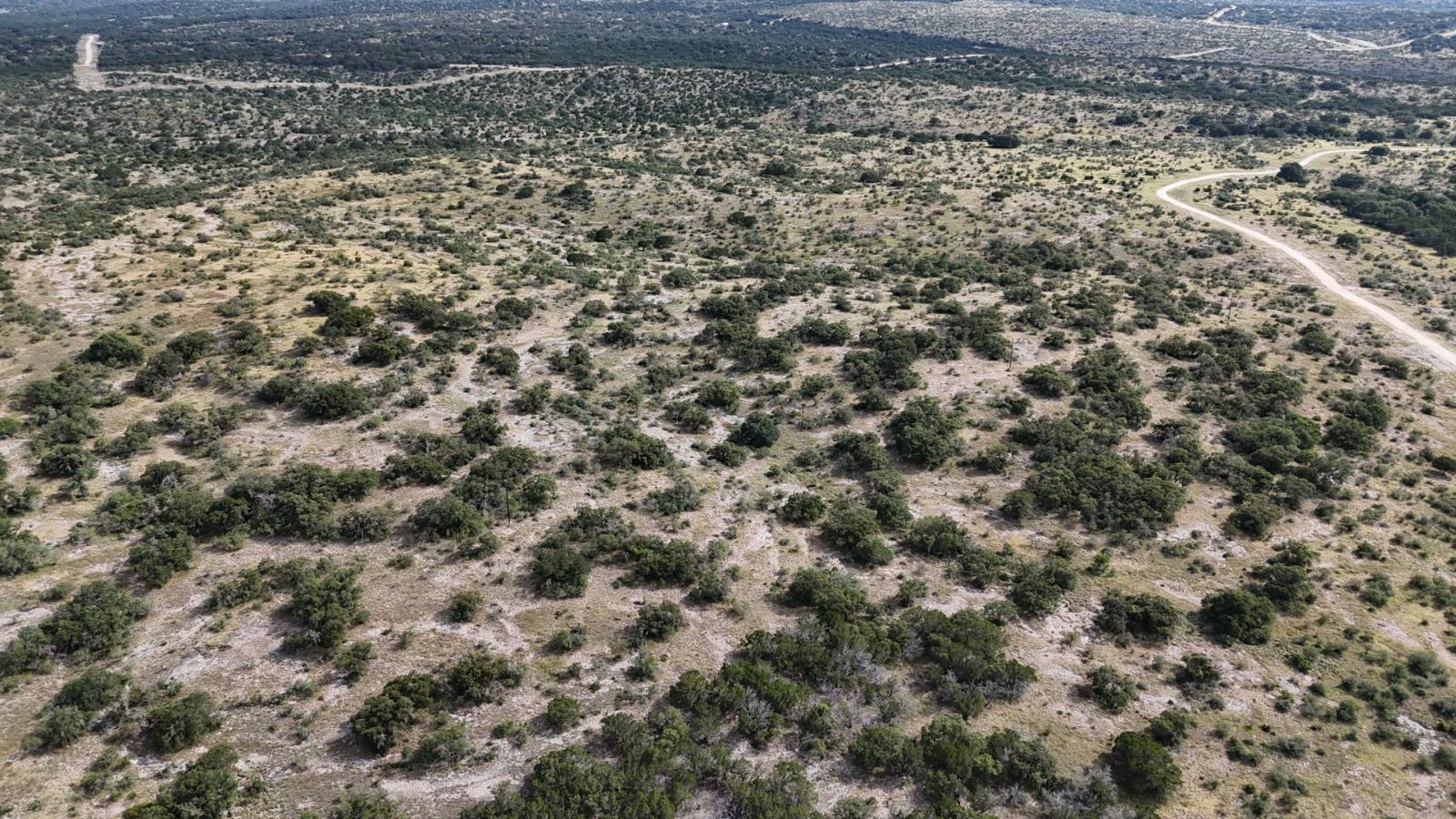
THE GROUND.
Two hills anchor this tract on Alamo Ranch, one riding the corner from southwest to southeast and another standing along the center of the west line, and between them the land settles into a low draw that runs clear to the north where it meets our road. That is 39.36 acres of Hill Country ranch land for sale in Edwards County, Texas, 13 miles south of Rocksprings off Highway 55. Walk it and you read the country in its shape: high ground on the flanks, a wide valley bottom pulling through the middle, and the kind of elevation change that makes a piece of land feel bigger than its acreage. The north end carries thicker brush, good cover that holds game, and as you move south and west that brush thins and opens the ground up. A power line crosses the middle of the tract running east to west, and electric already runs near the county road and at points across the wider ranch. That puts service within reasonable reach when the time comes to set a cabin or a camp house up on one of those rises, where you would catch the light coming across the valley and the quiet that comes with country this far from town. This is genuine Hill Country around Rocksprings, a stretch of Edwards County long known for its wildlife. Whitetail and axis deer work these draws, along with aoudad, elk, turkey, dove, and hogs, and the mix of thick northern cover and open southern ground gives them room to move and gives you room to watch. Rocksprings sits a short drive north, close enough for supplies and a meal yet far enough that the land stays secluded. San Antonio is a couple of hours southeast when you need the city, which is part of what makes country like this work for a weekend hunting camp, a place to retire to, or ground to hand down. The tract is surveyed with deeded access on our road, held under light restrictions with no commercial hunting, so you know what your neighbors can and cannot do. Come walk it, stand on one of these hills, and see how the valley falls away below you.
Property Features
- Deeded access: Yes
- Surveyed: Yes
Utilities
- Power available
- Water: confirm with Frank
Wildlife
Wildlife includes whitetail deer, turkey, axis deer, aoudad, elk, feral hogs, and dove.
Location
Edwards County, Texas. Located only 13 miles south of town off Highway 55 and County Road 310, the convenience of being so close yet secluded in the country makes the dream of owning land a reality.
SELLER FINANCING ESTIMATES
MAKE THE NUMBERS WORK.
Move the slider to update the estimated monthly payments for each down-payment option.
Listed price: $171,216.00
| Down % | Down payment | Amount financed | Rate | Monthly payment |
|---|---|---|---|---|
| 5% | $8,560.80 | $162,655.20 | 10.9% | $1,536.73/mo |
| 10% | $17,121.60 | $154,094.40 | 9.9% | $1,340.92/mo |
| 15% | $25,682.40 | $145,533.60 | 9.5% | $1,223.73/mo |
| 20% | $34,243.20 | $136,972.80 | 9.0% | $1,102.11/mo |
VETERAN SELLER FINANCING
Listed price $171,216.00
2% veteran discount −$3,424.32
Veteran price $167,791.68
| Down % | Down payment | Amount financed | Rate | Monthly payment |
|---|---|---|---|---|
| 5% | $8,389.58 | $159,402.10 | 9.9% | $1,387.10/mo |
| 10% | $16,779.17 | $151,012.51 | 8.9% | $1,204.23/mo |
| 15% | $25,168.75 | $142,622.93 | 8.5% | $1,096.65/mo |
| 20% | $33,558.34 | $134,233.34 | 8.0% | $984.96/mo |
Veteran seller-financing estimates using Ranch King’s veteran discount and rate schedule. Confirm eligibility and applicable terms with Frank.
Illustrative estimates using Ranch King’s financing rate schedule. Principal and interest only; taxes and other costs excluded. Confirm applicable rates, pricing, and terms with Frank.
5% minimum down · 1–30 year terms · No credit check · No pre-payment penalty · Warranty deed delivered at closing
Alamo Ranch
MAPS & DOCUMENTS.
Ranch overview & all tractsOpen Land ID map
If the map does not load here, open the Land ID map in a new tab.
Ranch restrictions
ALAMO RANCH RESTRICTIONS AND COVENANTS 1. That these covenants shall run with the land and shall be binding on the Purchaser and all persons claiming under them. Purchaser understands that these restrictions and covenants are filed in the Real Property Records of Edwards County, Texas referencing 8,839.55 acres recorded in Volume 461, Pg. 408-420. 2. Hunting of all kinds for all game or other animals, whether on foot or by vehicle, is prohibited on or from roads in the Ranch. The property shall not be used for commercial hunting. No seasonal lease or day lease hunting is permitted. All hunting leases are prohibited. Hunting is permitted by landowners and their guests only. 3. The property shall not be used for any commercial, short term rental, or manufacturing purposes. 4. There exists a grazing lease on this property. This lease shall be subordinate to any third-party lender deed of trust lien. Purchaser understands that livestock may be present on their land and that sources of water on their land that existed when the property was purchased may be used for said livestock. Purchaser has no obligation to continue this lease and may cancel the lease on their property by constructing fencing that meets local standards and is adequate to keep Lessee's livestock off the property and then giving Lessee at least 30 days advance written notice of termination. If Purchaser desires to remove or alter any existing fences on their property Lessee shall be notified at least 30 days in advance in order to maintain control of the livestock. 5. That no automobile, truck, trailer, or other vehicle shall be abandoned on this property, nor shall there be any dumping or placing of unsightly objects of any kind on the property. 6. That no structure of any kind (including hunting blinds and/or deer feeders) shall be permitted within 100 feet of any property line. All fencing must be set back thirty (30) feet from the centerline of all main access roads. 7. No noxious or offensive activity shall be carried on upon any tract, nor shall anything be done thereon which may constitute or become an annoyance or nuisance to any adjoining tract. No person shall engage in any illegal activity on the property, nor shall any tract be maintained or utilized in such a manner as to violate any applicable statute, ordinance or regulation of the United States of America, the State of Texas, the County of Edwards, or any other governing authority with jurisdiction. 8. Discharge of sewage from an RV, travel trailer, home or cabin on the property is strictly prohibited and illegal unless it is discharged into a permitted septic system (On Site Sewage Facility - OSSF) installed by a licensed installer. 9. Not more than one residence shall be permitted on any tract. No communal residences shall be permitted. RV’s and travel trailers may not be used as primary residences but are allowed for temporary use. All RV’s and travel trailers must adhere to setback requirements. 10. Commercial swine operations are strictly prohibited. 11. Purchaser agrees not to impede the flow of water in and to existing water lines, tanks, or troughs that are on the property and grants ingress and egress to persons who need to maintain said improvements and wells which furnish water to the lines, tanks or troughs. Only those Purchasers who own an interest in an existing well shall have the right to use water from said well unless water use is granted by the owners of the well. Seller will not furnish water to any existing water troughs or tanks. 12. That no tract may be subdivided without the express written consent of the Seller. 13. Purchaser is advised that the Property may be located in a 100-year floodplain. Even if the Property is not in a 100-year floodplain, the Property may still be susceptible to flooding. The Federal Emergency Management Agency (FEMA) maintains a flood map on its Internet website that is searchable by address, at no cost, to determine if real property is located in a flood hazard area. Most insurance policies do not cover damages or loss incurred in a flood. Purchaser should seek insurance coverage that would cover losses caused by a flood. Developer is not aware if the Property has flooded at least once within the last five years. 14. Seller has constructed or intends to construct a graded cliché/gravel covered road (the "Access Road") between the entrance of the development and the above-described property adequate in width for single vehicle access. Seller, by written instrument or by the plat, grants to Buyer or Buyer’s heirs and/or assigns, a non-exclusive easement right to use said Access Road for the purpose of ingress and egress to the property. Buyer is hereby notified that caliche or other material may be removed from their property to construct this road. Buyer understands that this is a common practice in the construction of this type of road and agrees that they will not be compensated for these activities. 15. Purchaser hereby authorizes Seller and/or Assigns to charge each property owner a maintenance fee of $5.00 per acre, per year, not to exceed $500.00 to improve and maintain entrances, roads, community wells, water lines, storage tanks and any other maintenance deemed necessary by the seller and/or Assigns. Tracts fronting on the county road shall have a maintenance fee of $3.00 per acre per year, not to exceed $500.00. Seller and/or Assigns shall not be subject to this charge. Such charge shall be made by direct billing to the property owner. If purchaser refuses to make said payments, purchaser hereby authorizes seller, at seller's option, to deduct such charge from payments made by purchaser, and any such charge so deducted will not be credited to the payment on the balance due on the purchase price, principal or interest. It is understood and agreed that this road maintenance charge (if not paid within 60 days of billing date) shall become a lien against the tract being conveyed, permitting seller and/or Assigns such rights to enforce said liens as may be set forth in Sec. 51.002 of the Texas Property Code, as amended from time to time. 16. At such time as seller determines, at their sole discretion, the seller shall have the authority but not the obligation to notify each tract owner of the time, date, and a place of a meeting of all tract owners to be held for the purpose of organizing a Property Owner's Association. A majority of the votes of the tract owners in attendance at such meetings or by written proxy shall be sufficient to transact business at such meeting. Each tract owner, including seller, attending or represented by written proxy at such meetings shall have one vote for each tract owned by such owner on all business to come before the meeting. Upon the creation and organization of such an association, whether as a non-profit corporation or other legal entity, seller shall transfer and assign to the association the current balance of the road improvement and maintenance, if any. Thereafter such association shall have the power, authority and obligation to maintain the roadways of the development and collect the road maintenance assessment. All such assessments upon any tract in the development shall become the personal obligation of the owners of such tract and such association is hereby granted a lien upon each lot to secure the payments of such assessments, permitting said association such rights to enforce said liens as may be set forth in Sec. 51.002 of the Texas Property Code, as amended time to time. It is understood that seller, or seller’s assigns, shall not be responsible for paying this assessment under any circumstances. In the event a lien has been placed on property to secure the payment of assessments and that property is repossessed or otherwise transferred to seller it is understood that all such liens will be released. 17. Purchaser agrees to comply with all applicable local water district regulations regarding the drilling of a new water well. 18. No deviation of any kind shall be permitted from these restrictions unless permission is granted in writing by the seller.
Tract map
Google Maps opens near the tract center. The outline shown here is approximate; confirm boundaries against the recorded survey and property documents.
Property information as of November 3, 2026. Confirm availability and details with Frank.